
By Albertis_Photography
Mount Wilhelm is the highest mountain in Papua New Guinea at 4,509 metres (14,793 ft). It is located in Simbu Province.
Mt. Wilhelm is named after Kaiser Wilhelm of Germany who first climbed the mountain in the mid-1930's.

Mount Wilhelm received its name in 1888 when a German newspaper correspondent, Hugo Zöller, climbed the Finisterre Range, south-east of Madang, and named the Bismarck Range after the German Chancellor, Otto von Bismarck, and the four highest peaks of the range after him and his children: Ottoberg, Herbertberg.
It is part of the Bismarck Range and the peak is the point where three provinces; Simbu, Jiwaka and Madang, meet.
Mount Wilhelm may be considered the highest mountain in Oceania (including Australia and New Zealand). A Seven Summits list may therefore sometimes include Mount Wilhelm.
The expedition crosses rivers, climbs through moss forests (home of several birds of paradise), alpine grasslands and glacial valleys. To add to this, there are amazing views of the North Coast and surrounding valleys. Once the summit is reached, the exit is by the usual summit route, down to Keglsugl via Lake Piunde.

This expedition will give you a great appreciation of highland life and custom.
#LIFE_ON_THE_MOUNTAIN
At the top of Mt. Wilhelm, Massif gets very cold indeed. Above 2700m frost occurs and at times snow falls above 4000m. Strong, cold winds are common and rain and mist can occur suddenly turning visibility to only a few metres.
The sky around Wilhelm is usually clear in the early morning, but by nine the fog that is laying low in valley, lifts.
Large cloud formations gather at higher altitudes and by midday intermittent mist and showers occur, usually until sunset. Summit attempts are usually made around 1am to avoid the mid-morning clouds. Views from the summit at sunrise are simply awesome.
#HEALTH_AND_SAFETY
Mt Wilhelm should not be underestimated. Exposure to the elements can be a problem, whether it's the cold or sunlight.
A combination of wind, wet clothing, fatigue and hunger, even if the air temperature is well above freezing, can lead to hyperthermia. Likewise, you can burn deceptively fast. There is less atmospheric protection at higher altitudes and the fact you're not hot doesn't mean you're not boiling.
Note:
While this is a non-technical trek, it is a difficult walk. In several places a steep scramble is required. The walk requires a reasonable level of fitness to complete.
Mt. Wilhelm in the Simbu language is called Enduwa Kombugu, and in the Upper Jimi Language (the language spoken in Ambullua) it is called Korikhl Khu.
It covers an area of about 100 sq. km/40 sq. miles. To the North is a steep drop off to the Ramu Valley (from over 4,000m/13,200ft to less than 600m/2,000ft in only 13km/8miles).
Its steep glacial valleys were carved out during the last ice-age (the Pleistocene period - approximately 10,000 years ago), the interface between the grasslands and the forest marks the snow line from this period. The mountain is climbed by both Papua New Guineans and International visitors alike via the normal Keglsugl route.
#SIMBU_CULTURE
All the tribal groups that live in the Simbu Province are known as the Simbu. The name is derived from simbu which means "very pleased".
Apparently, the first Europeans who walked through the region in the 1930's gave the locals gifts. The locals were very pleased with these gifts and responded by saying simbu, simbu!. The Europeans didn't know what they meant and thus called them and the area Simbu.
Approximately 8 distinct languages are spoken in the Simbu Province.
The MT. Wilhelm ascent can be done from a variety of differing routes however Escape Trekking Adventures chooses to use a moderately difficult route from Keglsugl in the Chimbu Province.
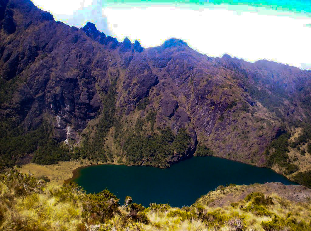
During your ascent of the Keglsugl route you will discover high elevation mountain rain forest, alpine grassland, moss coated forests and a glacial valley to the twin lakes of Piunde and Aunde (male and female name).
This takes from between three to four hours with 4 stops on the way. At Piunde (the lower lake) there are two huts, one being an old university monitoring station and the other an ‘A-Frame’ hut.
Though not a technical climb, once past Lake Aunde (the uppermost lake, which feeds Piunde), there are at least four sections where sure footing is essential; in wet weather various sections can be treacherous. It is essential that an afternoon trek to the top lake is taken to help the body adjust to the altitude.
MT. Wilhelm is one of the most accessible and beautiful mountain to climb in Papua New Guinea.
A government patrol officer Leigh Vial and two native papuans was the first successful recorded ascent of MT. Wilhelm on the 15th August 1938.
Many successful attempts to summit this mountain has been made along with a few disasters.
A handful of deaths have occurred while summiting mainly due to slips and falls into steep ravines. Professional care is needed in order to make this a safe and successful journey.
The Traditional name of MT. Wilhelm is Enduwa Kombuglu (local Kuman language name) and this forms a part of the Bismarck range that runs across 3 provinces of Papua New Guinea. The precise summit is surrounded by the 3 provinces of Chimbu, The Western Highlands and Madang.
MT. Wilhelm is named after Kaiser Wilhelm who was the first European to explore the area during the 1930’s.
MT. Wilhelm’s geographical land location has been from the date of independence customary land to the native landowners.
Not with standing the potential alienation of customary land within the national park area MT. Wilhelm was a declared national park and was managed by the National Parks Board and more recently by the Department of Environment and Conservation.
There has been little active management or recognition of the area as a protected area from the period of 1994 onwards though the Park would appear to still be statutorily declared as a protected area.
During World War II in the early hours of May 22, 1944, an American F-7A named “Under Exposed” crashed into the mountain while flying too low.
The aircraft left from Nadzab airbase, close to Lae, and had been assigned for a reconnaissance mission to photograph Padaidori Island in Dutch New Guinea.
Around 400 the plane crashed into Wilhelm at about 13,000 feet (4,000 m) above the twin lakes. All crew were killed and most of the wreckage landed in the topmost lake although some can still be seen today.
There are some remains at the site are from the plane.
Next : Taste The True Tranquility - Visit Lake Kutubu in PNG and be rewarded with Adventure